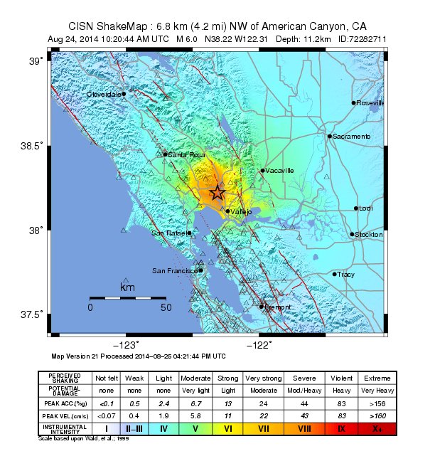
NAPA VALLEY, Calif. — A 6.0 earthquake struck Northern California in the early morning of August 24, 2014 causing an estimated $1 billion in damages to both commercial and residential properties.
The earthquake was the largest to hit the San Francisco Bay Area since 1989. Significant damage and several fires were reported in the southern Napa Valley area, and there was also damage in the adjacent city of Vallejo, in Solano County. The quake injured about 200 people and interrupted electric service to more than 69,000 customers.
Home insurance does not cover earthquake damage as a separate earthquake policy is required.
Many agents offer basic residential earthquake insurance for individually owned residential structures of less than five units, mobile homes, individual condominiums and townhouses or certain other common area development properties and rentals.
The estimates, by some accounts, could be in the hundreds of millions. But local, state and federal officials meeting the week following the quake could not get an accurate tally of the damage left behind from the weekend earthquake. Napa County Supervisor Mark Luce said it was difficult to get a clear dollar figure.
Some buildings, including the Napa municipal courthouse, were too dangerous to enter, so no one knows the actual damage. Civic leaders have sent out surveys to private companies but have not heard back from many, Luce said.
And aftershocks that shook the region following the large quake meant further evaluation of some structures might be needed.
Half of the region's wineries responding to a survey reported total damages estimated at $38 million. The threshold for the region to qualify for federal relief is $55 million, the amount of public buildings in the region that are not covered by insurance, Luce said.
Getting a jump on the bump
An Earthquake Early Warning System (EEW) for the west coast of the United States is being developed by the U. S. Geological Survey (USGS) along with California Institute of Technology, University of California at Berkeley and the University of Washington.
The USGS has the responsibility to issue alerts for earthquakes, to enhance public safety, and to reduce losses through effective forecasts and warnings. USGS currently issues rapid, automatic earthquake information via the Internet, email, text messages and social media.
EEW uses existing seismic networks to detect moderate to large earthquakes very rapidly so that a warning can be sent before destructive seismic waves arrive at locations outside the area where the earthquake begins. These warnings allow people to take protective action and can also triggering automatic responses to safeguard critical infrastructure.
Earthquake early warning can be used to slow and stop trains, alert and protect critical infrastructure and provide a few seconds for people to take cover.
Such actions might include:
· allow people to drop, cover and hold on
· provide businesses time to shut down and move workers to safe locations,
· give medical professionals time to stop delicate procedures,
· protect travelers by providing time for trains to slow or stop,
for elevator doors to open, for bridge traffic to clear,
for slowing or stopping traffic and even stopping landings and take-offs at airports,
· enable emergency responders to prepare by opening fire station doors.
For more information about earthquake protection contact your PCIIA agent.
=  |
|
|