by Joe Evancho and ISU
POCATELLO, Idaho — Firefighters battling the 100-square-mile Big Cougar wildfire in Idaho used a Geographic Information Systems satellite (GIS) imagery decision support system to help with planning wildfire recovery. The system was designed by Idaho State University’s GIS Training and Research Center and NASA.
This system was successfully tested in Idaho in 2013 and will be expanded for use throughout the western United States. I twill help fire managers battle the large blazes throughout the West.
“This is a game changer for wildfire prevention, management, mitigation and recovery after a fire,” said Dr. Howard Grimes, ISU Vice President for Research and Economic Development. “Using big data approaches to solving real problems is a new and critical direction for GIS researchers.”
It takes only five minutes for the Rehabilitation Capability Convergence for Ecosystem Recovery (RECOVER) system to produce a detailed report that gives the Bureau of Land Management,, or other agency wildfire managers, the information they needed to plan the recovery of a wildfire while actively fighting of a wildfire.
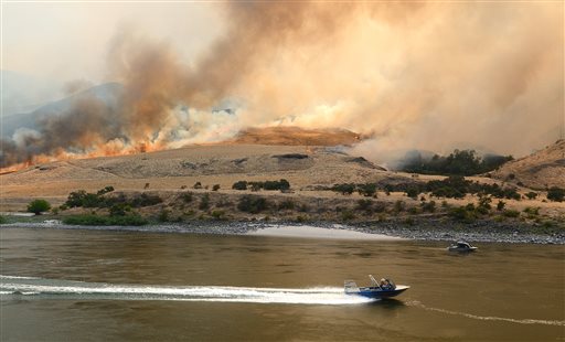
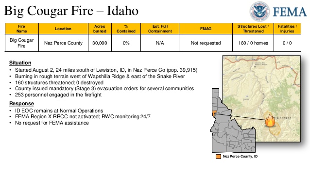
The Big Cougar wild land fire was lightning-caused and reported on August 2, 2014
about 24 miles south of Lewiston, ID on the Snake River.
That is 30 minutes less than it took in 2013.
In the past, the information collected on everything from burn severity and fire intensity to slope, vegetation and soil type would have taken weeks to collect and distribute. Now the that information is available to firefighters in the field on their cell phones and other mobile devices and to managers on their computers in remote locations.
RECOVER was developed in 2013 with funding from NASA’s Applied Sciences Program. During the next three years, with an additional $1 million in funding, this innovative program and firefighting tool will be expanded to be used in states including California, Colorado, Utah, Nevada, Oregon, Washington, Montana, Wyoming and Arizona.
Its creators and emergency managers are only now beginning to understand the many uses for RECOVER.
“It can be used for recovery following any natural disaster; earthquakes, large landslides, hurricanes and other disasters of similar magnitude,” said Keith Weber, director of the ISU GIS Training and Research Center and principal investigator on the project.
“It is a framework and a foundation to support decisions on recovery management during, just after an event and for long-term management.”
The new program, while still in its testing phase, proved its worth in 2013 on large fires in Idaho such as Pony and Elk Creek Complex Wildfire in south-central Idaho.
“We have data for Idaho now, but soon data will be available for the rest of the Western United States as we expand RECOVER’s scope,” Weber said.
NASA and ISU initially partnered with the BLM and the Idaho Department of Lands, but plan to extend their partnerships to the U.S. Geological Survey, U.S. Forest Service, the National Park Service, Idaho Transportation Department and other agencies.
“We’re very excited about moving RECOVER into operational use over the next three years, and involving other partner agencies is a huge boost to the project. RECOVER is an important contribution by NASA’s Applied Sciences Program to the nation’s wildfire management efforts,” said John Schnase, senior computer scientist at the NASA Goddard Space Flight Center.
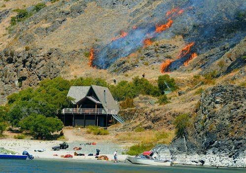
Several structures were threatened by the Big Cougar blaze.